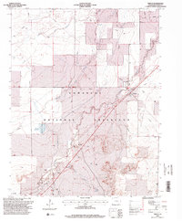
1996 Map of Timpas
USGS Topo · Published 2000About this map
The Santa Fe National Historic Trail cuts a diagonal path through this portion of Otero County, following the same corridor as the Atchison Topeka and Santa Fe railroad. Much of the landscape is dominated by the Comanche National Grassland, where the high plains environment is etched by seasonal watercourses like West Dry Creek and Timpas Creek. In the late 20th century, the small settlement of Timpas remains a focal point near several Historical Markers and a small Cem, while Ayer serves as a named siding or station further south along the rail line. The presence of Brown Reservoir and various water features like the Flowing Well underscores the importance of water management in this arid grazing territory, while the Hoe Ranch and Red Rock Road indicate the local ranching infrastructure.
Find a feature on this map
20 named features on this map. Tap any name to fly to it.
Don’t see what you’re looking for? This feature index may not catch every label — zoom into the map to look around manually.
Map Details
Editions of this 1996 Timpas Map
This is the sole edition of this map. No revisions or reprints were ever made.
Other maps of this area

1891 · Timpas
USGS Topo · 1:125,000

1894 · Timpas
USGS Topo · 1:125,000

1955 · La Junta
USGS Topo · 1:250,000

1958 · La Junta
USGS Topo · 1:250,000

1965 · La Junta SW
USGS Topo · 1:24,000
1966 · Hawley
USGS Topo · 1:24,000

1968 · La Junta
USGS Topo · 1:250,000
1972 · Timpas NE
USGS Topo · 1:24,000

1972 · Packers Gap
USGS Topo · 1:24,000
1972 · Timpas SW
USGS Topo · 1:24,000