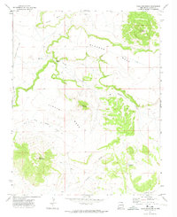
1971 Map of Tinaja Mountain
USGS Topo · Published 1974About this map
Tinaja Mountain and the high plateaus of Colfax County define this landscape as it was documented in the early 1970s. The topography is dominated by extensive flat-topped features, including Blosser Mesa, Tinaja Mesa, and Dwyer Mesa, which are separated by dramatic drops and natural passage points like Blosser Gap. The map provides specific points of interest for local history, notably a small Cem located near the West Fork Tinaja Creek. Drainage patterns are clearly marked by the winding paths of Blosser Arroyo and Granny Creek, while reliable water sources are identified at Cottonwood Spring and other unnamed springs. Eagle Tail Road skirts the western edge of the mesas, tracing a route through this high-elevation terrain where individual peaks like Red Mountain and Green Mountain rise above the surrounding tablelands.
Find a feature on this map
15 named features on this map. Tap any name to fly to it.
Don’t see what you’re looking for? This feature index may not catch every label — zoom into the map to look around manually.
Map Details
Editions of this 1971 Tinaja Mountain Map
This is the sole edition of this map. No revisions or reprints were ever made.
Other maps of this area

1912 · Raton
USGS Topo · 1:62,500

1914 · Raton
USGS Topo · 1:62,500

1954 · Raton
USGS Topo · 1:250,000

1958 · Raton
USGS Topo · 1:250,000

1971 · Clifton House
USGS Topo · 1:24,000

1971 · Tres Hermanos Peak
USGS Topo · 1:24,000
1971 · Eagle Tail Mountain
USGS Topo · 1:24,000
1971 · Loco Arroyo
USGS Topo · 1:24,000
1971 · Hunter Mesa
USGS Topo · 1:24,000

1971 · Johnson Park
USGS Topo · 1:24,000