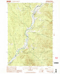
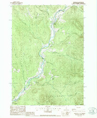
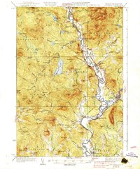
1988 Map of Tinkerville
USGS Topo · Published 1988About this map
The Connecticut River serves as the central artery and boundary of this Vermont and New Hampshire borderland, winding through a corridor of small settlements and rugged elevation. Small communities like Tinkerville and Columbia are anchored to the riverbank, joined by the historic Columbia Bridge. The landscape is defined by its dramatic relief, rising from the river valley to prominent summits such as Snow Hill, Ledge Mtn, and Mt Pleasant. Local industry and land use are evident in the presence of a Gravel Pit near Simms Hill and a Quarry further south. The map documents a rural economy where transport and geography meet at the water, from the northern reaches of Wallace Pond down to the rail-side settlement of North Stratford.
Find a feature on this map
44 named features on this map. Tap any name to fly to it.
Don’t see what you’re looking for? This feature index may not catch every label — zoom into the map to look around manually.
Map Details
Editions of this 1988 Tinkerville Map
3 editions found

Other maps of this area

1920 · Guildhall
USGS Topo · 1:62,500

1929 · Averill
USGS Topo · 1:62,500

1930 · Percy
USGS Topo · 1:62,500

1930 · Dixville
USGS Topo · 1:62,500

1931 · Guildhall
USGS Topo · 1:48,000

1933 · Guildhall
USGS Topo · 1:48,000

1933 · Dixville
USGS Topo · 1:62,500

1934 · Percy
USGS Topo · 1:62,500

1934 · Dixville
USGS Topo · 1:62,500
1937 · Guildhall
USGS Topo · 1:62,500