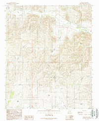
1989 Map of Tinnie
USGS Topo · Published 1989About this map
Rio Hondo defines the northern edge of this high-desert landscape, where the settlements of Tinnie and Picacho sit along the valley floor. The terrain is a complex network of deep drainages, including Casey Canyon, Gallo Canyon, and Bonney Canyon, which cut through the uplands south of the river. This 1989 provisional survey reveals a remote ranching economy dependent on scattered water sources. Numerous named wells such as Galles Well, Trouble Well, and Divide Well are positioned throughout the territory to sustain livestock in the arid environment. A small Cem near Picacho and a remote Landing Strip suggest the isolation of these communities. These features, along with small water bodies like Galles Lake and Lost Lake, illustrate the vital importance of water management in Lincoln County's canyon country during the late twentieth century.
Find a feature on this map
23 named features on this map. Tap any name to fly to it.
Don’t see what you’re looking for? This feature index may not catch every label — zoom into the map to look around manually.
Map Details
Editions of this 1989 Tinnie Map
This is the sole edition of this map. No revisions or reprints were ever made.
Other maps of this area

1955 · Roswell
USGS Topo · 1:250,000

1958 · Roswell
USGS Topo · 1:250,000

1961 · Flying H
USGS Topo · 1:62,500

1961 · Lincoln
USGS Topo · 1:62,500

1961 · Tinnie
USGS Topo · 1:62,500

1962 · Roswell
USGS Topo · 1:250,000

1963 · Deadman Lake
USGS Topo · 1:24,000

1984 · Ruidoso
USGS Topo · 1:100,000
1988 · Nelson Canyon East
USGS Topo · 1:24,000
1988 · Sunset
USGS Topo · 1:24,000