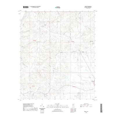
2020 Map of Tinsley
USGS Topo · Published 2020About this map
The community of Tinsley and the nearby Oil City anchor this Yazoo County landscape, where the local economy and road network are deeply intertwined with the region's energy history. Numerous local roads, such as Anding Oil City Rd and Tinsley Rd, connect these settlements to Anding and the crossing at Bentonia. The terrain is defined by a dense network of watercourses, including Mound Creek, Sandy Creek, and Thompson Creek, which carve through the land between the ridges. Genealogists will find several well-preserved landmarks of the area's rural heritage, notably the Cessna Cemetery, Hudson Cemetery, and Old Concord Cemetery near Little Yazoo. The map details a transition from the elevated uplands down toward the creek bottoms, tracing family-named routes like Broocks Rd and Henderson Rd.
Find a feature on this map
62 named features on this map. Tap any name to fly to it.
Don’t see what you’re looking for? This feature index may not catch every label — zoom into the map to look around manually.
Map Details
Editions of this 2020 Tinsley Map
This is the sole edition of this map. No revisions or reprints were ever made.
Other maps of this area

1940 · Mechanicsburg
USGS Topo · 1:62,500

1955 · Jackson
USGS Topo · 1:250,000

1961 · Jackson
USGS Topo · 1:250,000

1961 · Bayland
USGS Topo · 1:62,500

1961 · Valley
USGS Topo · 1:62,500

1962 · Jackson
USGS Topo · 1:250,000

1962 · Flora
USGS Topo · 1:62,500

1963 · Mechanicsburg
USGS Topo · 1:62,500

1984 · Yazoo City
USGS Topo · 1:100,000
1988 · Benton
USGS Topo · 1:24,000