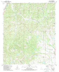
1988 Map of Tinsley
USGS Topo · Published 1989About this map
Tinsley and Oil City serve as the primary hubs in this late-1980s landscape, where the local economy is defined by petroleum infrastructure and rail transit. The Illinois Central Gulf RR cuts through the eastern half of the quadrangle, connecting the communities of Anding and Little Yazoo. A network of underground Pipeline segments crisscrosses the central hills, reflecting the region's industrial focus during this era.
Find a feature on this map
29 named features on this map. Tap any name to fly to it.
Don’t see what you’re looking for? This feature index may not catch every label — zoom into the map to look around manually.
Map Details
Editions of this 1988 Tinsley Map
This is the sole edition of this map. No revisions or reprints were ever made.
Other maps of this area

1940 · Mechanicsburg
USGS Topo · 1:62,500

1955 · Jackson
USGS Topo · 1:250,000

1961 · Jackson
USGS Topo · 1:250,000

1961 · Bayland
USGS Topo · 1:62,500

1961 · Valley
USGS Topo · 1:62,500

1962 · Jackson
USGS Topo · 1:250,000

1962 · Flora
USGS Topo · 1:62,500

1963 · Mechanicsburg
USGS Topo · 1:62,500

1984 · Yazoo City
USGS Topo · 1:100,000
1988 · Benton
USGS Topo · 1:24,000