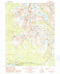
1990 Map of Tioga Pass
USGS Topo · Published 1990About this map
Tuolumne Meadows and the high Sierra peaks define this high-altitude landscape where Yosemite National Park, Hoover Wilderness, and Inyo National Forest converge. The terrain is marked by the Conness Glacier beneath Mount Conness, surrounded by a dense network of alpine water bodies including Saddlebag Lake, McCabe Lakes, and the Gaylor Lakes. Evidence of early industrial and scientific interest in the region remains visible through the Great Sierra Mine, the Hess Mine, and the Carnegie Institute Experimental Station. Near the southern edge, the map details the visitor infrastructure around the Tioga Road corridor, featuring Parsons Memorial Lodge, Soda Springs, and Lembert Dome. The presence of Bennettville reflects the area's mining history, while the proximity of various campgrounds and the Tioga Pass entry point highlights its role as a critical transition between the Yosemite high country and the eastern Sierra slope.
Find a feature on this map
73 named features on this map. Tap any name to fly to it.
Don’t see what you’re looking for? This feature index may not catch every label — zoom into the map to look around manually.
Map Details
Editions of this 1990 Tioga Pass Map
This is the sole edition of this map. No revisions or reprints were ever made.
Other maps of this area

1901 · Mt. Lyell
USGS Topo · 1:125,000

1909 · Bridgeport
USGS Topo · 1:125,000

1911 · Bridgeport
USGS Topo · 1:125,000

1920 · Bridgeport
USGS Topo · 1:125,000

1947 · Mariposa
USGS Topo · 1:250,000

1948 · Walker Lake
USGS Topo · 1:250,000

1948 · Mariposa
USGS Topo · 1:250,000

1953 · Mono Craters
USGS Topo · 1:62,500

1956 · Matterhorn Peak
USGS Topo · 1:62,500

1956 · Tuolumne Meadows
USGS Topo · 1:62,500