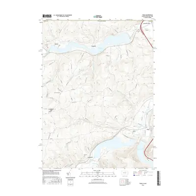
2016 Map of Tioga
USGS Topo · Published 2016About this map
Cowanesque Lake and the Tioga Reservoir dominate this northern Pennsylvania landscape, where the Cowanesque River and Tioga River converge near the New York border. The area is defined by its water management and agricultural valleys, with settlements like Lawrenceville and Nelson situated along the historic river corridors. The terrain rises sharply from the basins to ridges like Sugar Ridge, revealing a network of rural roads that connect upland communities such as Farmington Hill to the valley floors.
Find a feature on this map
73 named features on this map. Tap any name to fly to it.
Don’t see what you’re looking for? This feature index may not catch every label — zoom into the map to look around manually.
Map Details
Editions of this 2016 Tioga Map
This is the sole edition of this map. No revisions or reprints were ever made.
Other maps of this area

1900 · Tioga
USGS Topo · 1:62,500

1900 · Elkland
USGS Topo · 1:62,500

1902 · Tioga
USGS Topo · 1:62,500

1914 · Corning
USGS Topo · 1:62,500

1924 · Woodhull
USGS Topo · 1:48,000

1926 · Woodhull
USGS Topo · 1:62,500

1944 · Woodhull
USGS Topo · 1:62,500

1944 · Corning
USGS Topo · 1:62,500

1950 · Elmira
USGS Topo · 1:250,000
1953 · Borden
USGS Topo · 1:24,000