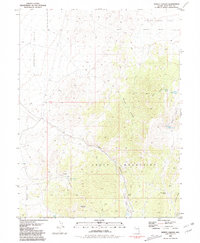
1981 Map of Tippett Canyon
USGS Topo · Published 1981About this map
The Goshute Indian Reservation Boundary borders the northeastern portion of this High Desert landscape, where the South Mountains dominate the central and southern terrain. This 1981 survey documents a region defined by high-altitude ranching and mining potential, with small outposts such as Refuge and a Corral situated near the broad expanse of Antelope Valley. The presence of several vital water sources, including Coyote Spring, Moffitt Spring, and Blind Spring, highlights the critical importance of localized springs for survival and livestock in this arid environment.
Find a feature on this map
26 named features on this map. Tap any name to fly to it.
Don’t see what you’re looking for? This feature index may not catch every label — zoom into the map to look around manually.
Map Details
Editions of this 1981 Tippett Canyon Map
This is the sole edition of this map. No revisions or reprints were ever made.
Other maps of this area

1956 · Ely
USGS Topo · 1:250,000

1959 · Ely
USGS Topo · 1:250,000

1963 · Ely
USGS Topo · 1:250,000

1979 · Sunset Reservoir
USGS Topo · 1:24,000
1981 · Spring Creek Flat NW
USGS Topo · 1:24,000
1981 · Georgetta Ranch
USGS Topo · 1:24,000
1981 · Weaver Canyon
USGS Topo · 1:24,000
1986 · Grass Valley Wash
USGS Topo · 1:24,000
1986 · Tippett
USGS Topo · 1:24,000
1986 · Blue Mass Canyon
USGS Topo · 1:24,000