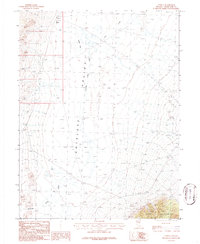
1986 Map of Tippett
USGS Topo · Published 1986About this map
Tippett stands as the primary namesake settlement in this high-desert landscape of eastern Nevada, recorded during a 1981 field check. The terrain is dominated by the Antelope Valley Depression, a low-lying basin where water drainage is marked by numerous dry lakes and the seasonal Antelope Valley Wash. To the southeast, the topography rises sharply into the Kern Mountains, where early industrial activity is evidenced by a Prospect and a Gravel Pit.
Find a feature on this map
15 named features on this map. Tap any name to fly to it.
Don’t see what you’re looking for? This feature index may not catch every label — zoom into the map to look around manually.
Map Details
Editions of this 1986 Tippett Map
This is the sole edition of this map. No revisions or reprints were ever made.
Other maps of this area

1956 · Ely
USGS Topo · 1:250,000

1959 · Ely
USGS Topo · 1:250,000

1963 · Ely
USGS Topo · 1:250,000

1979 · Sunset Reservoir
USGS Topo · 1:24,000
1981 · Tippett Canyon
USGS Topo · 1:24,000
1981 · Spring Creek Flat NW
USGS Topo · 1:24,000
1986 · Baldy Peak
USGS Topo · 1:24,000
1986 · Tippett Pass
USGS Topo · 1:24,000
1986 · Grass Valley Wash
USGS Topo · 1:24,000
1986 · Rock Springs Pass
USGS Topo · 1:24,000