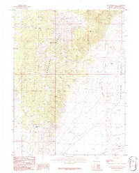
1986 Map of Rock Springs Pass
USGS Topo · Published 1986About this map
Antelope Range dominates this mid-1980s terrain, where the high ridges of the eastern Great Basin overlook the broad expanse of Antelope Valley. The placement of water sources was critical for the ranching and wildlife in this arid landscape, evidenced by Rock Springs and the functional Dipping Tank Spring. This provisional survey illustrates the relationship between the dramatic vertical relief of features like The Mitten and the drainage patterns that carved Red Rock Canyon. To the southeast, the terrain descends into a significant geological Depression and the Antelope Valley Wash, marking the transition from mountainous outcrops like Red Rocks to the valley floor. The map serves as a record of these reliable water points, including Antelope Spring, which have long anchored human and animal movement through White Pine County.
Find a feature on this map
10 named features on this map. Tap any name to fly to it.
Don’t see what you’re looking for? This feature index may not catch every label — zoom into the map to look around manually.
Map Details
Editions of this 1986 Rock Springs Pass Map
This is the sole edition of this map. No revisions or reprints were ever made.
Other maps of this area

1956 · Ely
USGS Topo · 1:250,000

1959 · Ely
USGS Topo · 1:250,000

1963 · Ely
USGS Topo · 1:250,000

1979 · Sunset Reservoir
USGS Topo · 1:24,000
1982 · Becky Peak
USGS Topo · 1:24,000
1982 · Silver Canyon
USGS Topo · 1:24,000
1982 · Stonehouse
USGS Topo · 1:24,000
1986 · Baldy Peak
USGS Topo · 1:24,000
1986 · Tippett Pass
USGS Topo · 1:24,000
1986 · Grass Valley Wash
USGS Topo · 1:24,000