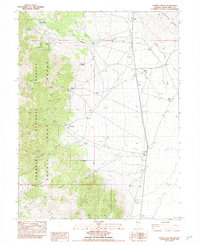
1982 Map of Silver Canyon
USGS Topo · Published 1982About this map
The Schell Creek Range dominates the western half of this 1982 provisional survey, providing a backdrop for the remote mining and ranching outposts of White Pine County. High mountain terrain within the Humboldt National Forest gives way to the broad expanse of Spring Valley to the east. Evidence of the region’s mineral history is carved into the slopes at the Siegel Mines and the Greek American Mine near the head of Silver Canyon. In the lowlands, water management is the primary driver of settlement, as seen in the system of ditches and name-bearing water sources like Osborne Springs and Willow Spring. The map documents small, scattered clusters including the settlement of Aurum and family-held locations like Siegel Ranch and Doutre Ranch, illustrating the sparse, resource-driven residency of the high Great Basin.
Find a feature on this map
28 named features on this map. Tap any name to fly to it.
Don’t see what you’re looking for? This feature index may not catch every label — zoom into the map to look around manually.
Map Details
Editions of this 1982 Silver Canyon Map
This is the sole edition of this map. No revisions or reprints were ever made.
Other maps of this area

1956 · Ely
USGS Topo · 1:250,000

1959 · Ely
USGS Topo · 1:250,000

1963 · Ely
USGS Topo · 1:250,000
1982 · Kalamazoo Creek
USGS Topo · 1:24,000
1982 · Stonehouse
USGS Topo · 1:24,000
1982 · Schellbourne
USGS Topo · 1:24,000
1982 · Mattier Creek
USGS Topo · 1:24,000
1982 · Kalamazoo Summit
USGS Topo · 1:24,000
1986 · Big Hard Pan
USGS Topo · 1:24,000
1986 · Tippett Pass
USGS Topo · 1:24,000