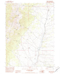
1982 Map of Becky Peak
USGS Topo · Published 1982About this map
Becky Peak rises as the prominent landmark of the Schell Creek Range in this high-altitude Nevada survey. The landscape is defined by its arid-land water management, where numerous natural water sources like Mustang Spring, Gravel Spring, and Skull Spring are supplemented by man-made interventions. The presence of irrigation infrastructure, including an Aband Ditch and an Abd Ditch near Sampson Creek, reflects the historical efforts to divert water from the mountain runoff to the valley floor for ranching or agricultural use.
Find a feature on this map
19 named features on this map. Tap any name to fly to it.
Don’t see what you’re looking for? This feature index may not catch every label — zoom into the map to look around manually.
Map Details
Editions of this 1982 Becky Peak Map
This is the sole edition of this map. No revisions or reprints were ever made.
Other maps of this area

1955 · Elko
USGS Topo · 1:250,000

1956 · Ely
USGS Topo · 1:250,000

1958 · Elko
USGS Topo · 1:250,000

1959 · Ely
USGS Topo · 1:250,000

1962 · Elko
USGS Topo · 1:250,000

1963 · Ely
USGS Topo · 1:250,000

1965 · Elko
USGS Topo · 1:250,000

1982 · Chin Creek Spring
USGS Topo · 1:24,000

1982 · Cherry Spring
USGS Topo · 1:24,000
1982 · Goshute Lake South
USGS Topo · 1:24,000