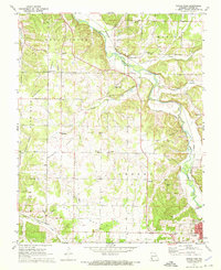
1972 Map of Tipton Ford
USGS Topo · Published 1973About this map
Shoal Creek meanders across this Newton County landscape, where the Kansas City Southern railroad dictates the local geography of settlements like Tipton Ford and Baynham. The area is defined by its agricultural and mining history, evident in the several large tailings piles located near Spurgeon and the broad expanse of Burkhart Prairie and Brock Prairie. This survey captures a rural network of small communities and family landmarks just as modern development began to reach the northern edges of Neosho. Local history is preserved in the numerous country churches and burial grounds that dot the hills, including the Cave Spring Ch and Cedar Creek Cem. The map provides a detailed view of the infrastructure of the early 1970s, from a local Substation and Townhall to the winding course of the Scenic Road through the eastern timber.
Find a feature on this map
41 named features on this map. Tap any name to fly to it.
Don’t see what you’re looking for? This feature index may not catch every label — zoom into the map to look around manually.
Map Details
Editions of this 1972 Tipton Ford Map
This is the sole edition of this map. No revisions or reprints were ever made.
Other maps of this area

1886 · Joplin
USGS Topo · 1:125,000

1886 · Carthage
USGS Topo · 1:125,000

1894 · Joplin
USGS Topo · 1:125,000

1894 · Carthage
USGS Topo · 1:125,000

1907 · Wyandotte
USGS Topo · 1:125,000

1909 · Wyandotte
USGS Topo · 1:125,000

1916 · Neosho
USGS Topo · 1:62,500

1947 · Joplin
USGS Topo · 1:250,000

1949 · Joplin
USGS Topo · 1:250,000

1949 · Seneca
USGS Topo · 1:24,000