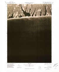
1977 Map of Tisbury Great Pond
USGS Topo · Published 1981About this map
Marthas Vineyard is seen here through high-altitude aerial photography captured in 1977, revealing the intricate coastal morphology of the island's southern shore. The landscape is dominated by the sprawling brackish waters of Tisbury Great Pond, which is separated from the Atlantic Ocean by a narrow barrier beach. This orthophotograph, published by the Geological Survey in coordination with the Commonwealth of Massachusetts Department of Public Works, provides a clear view of land use and vegetation patterns during the late 1970s. Key local landmarks and traditional sites such as Quansoo, Tississa, and Nabs Corner are labeled, anchoring the photographic detail to the named geography of the region. The map highlights the interplay of narrow inlets and coastal plains that characterize this part of Dukes County.
Find a feature on this map
6 named features on this map. Tap any name to fly to it.
Don’t see what you’re looking for? This feature index may not catch every label — zoom into the map to look around manually.
Map Details
Editions of this 1977 Tisbury Great Pond Map
This is the sole edition of this map. No revisions or reprints were ever made.
Other maps of this area

1887 · Gay Head
USGS Topo · 1:62,500

1887 · Marthas Vineyard
USGS Topo · 1:62,500

1889 · Gay Head
USGS Topo · 1:62,500

1889 · Marthas Vineyard
USGS Topo · 1:62,500

1893 · Gay Head
USGS Topo · 1:62,500

1894 · Marthas Vineyard
USGS Topo · 1:62,500

1942 · Marthas Vineyard
USGS Topo · 1:125,000

1944 · Tisbury Great Pond
USGS Topo · 1:31,680

1944 · Vineyard Haven
USGS Topo · 1:31,680
1944 · Edgartown
USGS Topo · 1:31,680