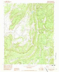
1982 Map of Todilto Park
USGS Topo · Published 1983About this map
The Navajo Indian Reservation landscape within the Chuska Mountains is defined by striking geological formations and intermittent watercourses. In this late 1970s environment, dramatic monoliths like Venus Needle and Cleopatras Needle stand as prominent landmarks above Bowl Wash. The geography is shaped by high-elevation features such as Pine Ridge and Dividing Ridge, which overlook a network of seasonal drainages including Tohdildonih Wash and Twin Buttes Wash. Reliable water sources are rare in this terrain, making features like Bowl Lake and Squirrel Springs critical points of interest. These springs and washes dictated the movement and land use patterns for those living in the shadow of the peaks, where the transition from high ridgelines to deep washes creates a complex topographical tapestry for study.
Find a feature on this map
16 named features on this map. Tap any name to fly to it.
Don’t see what you’re looking for? This feature index may not catch every label — zoom into the map to look around manually.
Map Details
Editions of this 1982 Todilto Park Map
This is the sole edition of this map. No revisions or reprints were ever made.
Other maps of this area

1886 · Wingate
USGS Topo · 1:250,000

1886 · Fort Defiance
USGS Topo · 1:250,000

1889 · Chaco
USGS Topo · 1:250,000

1892 · Fort Defiance
USGS Topo · 1:250,000

1892 · Wingate
USGS Topo · 1:250,000

1892 · Chaco
USGS Topo · 1:250,000

1892 · Canyon De Chelly
USGS Topo · 1:250,000

1954 · Shiprock
USGS Topo · 1:250,000

1954 · Gallup
USGS Topo · 1:250,000

1955 · Zith-Tusayan Butte 1 SE
USGS Topo · 1:24,000