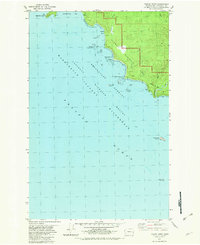
1982 Map of Toleak Point
USGS Topo · Published 1982About this map
The Pacific shoreline of the Olympic Peninsula is defined by a jagged collection of sea stacks and rocky outcroppings in this 1982 coastal survey. Within the Olympic National Park boundary, the coast is punctuated by the dramatic formations of the Quillayute Needles and the Giants Graveyard, reflecting the erosive power of the ocean against the land. Inland, the landscape rises toward the east, where the waters of Jackson Creek and Goodman Creek carve through the forested terrain before reaching the sea. Small pockets of shelter, such as those at Toleak Point and Strawberry Pt, provide some relief along a coastline dominated by prominent headlands like Teahwhit Head and Scotts Bluff. Offshore, the Washington Islands Wilderness protects isolated features such as Alexander Island and Perkins Reef, emphasizing the remote, marine-focused character of this Jefferson County territory.
Find a feature on this map
23 named features on this map. Tap any name to fly to it.
Don’t see what you’re looking for? This feature index may not catch every label — zoom into the map to look around manually.
Map Details
Editions of this 1982 Toleak Point Map
This is the sole edition of this map. No revisions or reprints were ever made.
Other maps of this area

1939 · Forks
USGS Topo · 1:62,500

1943 · Copalis Beach
USGS Topo · 1:250,000

1951 · Copalis Beach
USGS Topo · 1:250,000

1956 · Destruction Island
USGS Topo · 1:62,500

1956 · La Push
USGS Topo · 1:62,500

1957 · Forks
USGS Topo · 1:62,500

1957 · Copalis Beach
USGS Topo · 1:250,000

1963 · Copalis Beach
USGS Topo · 1:250,000
1981 · Forks
USGS Topo · 1:24,000
1982 · La Push
USGS Topo · 1:24,000