
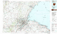
1900 Map of Toledo
USGS Topo · Published 1932About this map
The Maumee River serves as the industrial and logistical spine for Toledo at the turn of the century, a period when the city's growth was deeply intertwined with an extensive network of iron and water. This survey illustrates a complex web of railroads, including the Lake Shore and Michigan Southern R. R. and the Detroit and Toledo Shore Line R. R., converging on the waterfront and the Michigan Division Canal. Beyond the urban core, the landscape reveals a mix of institutional and industrial sites, such as the Toledo Insane Asylum and several Oil Wells south of Perrysburg. Smaller settlements like Sylvania, Holland, and Maumee are shown as established hubs along the rail lines, while the Northern Boundary of Twelvemile Reservation remains a significant cadastral landmark across the townships of Springfield and Adams.
Find a feature on this map
60 named features on this map. Tap any name to fly to it.
Don’t see what you’re looking for? This feature index may not catch every label — zoom into the map to look around manually.
Map Details
Editions of this 1900 Toledo Map
This is the sole edition of this map. No revisions or reprints were ever made.
Historical Maps of Toledo Through Time
12 maps found
1900 Toledo
Lucas County, OH
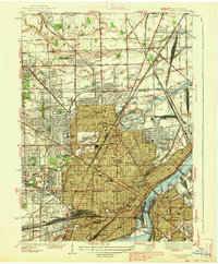
1938 Toledo
Lucas County, OH
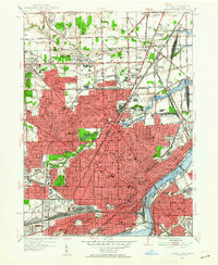
1952 Toledo
Lucas County, OH
1956 Toledo
Lucas County, OH

1961 Toledo
Lucas County, OH
1965 Toledo
Lucas County, OH
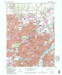
1986 Toledo
Lucas County, OH
2011 Toledo
Lucas County, OH
2013 Toledo
Lucas County, OH
2016 Toledo
Lucas County, OH
2019 Toledo
Lucas County, OH
2023 Toledo
Lucas County, OH