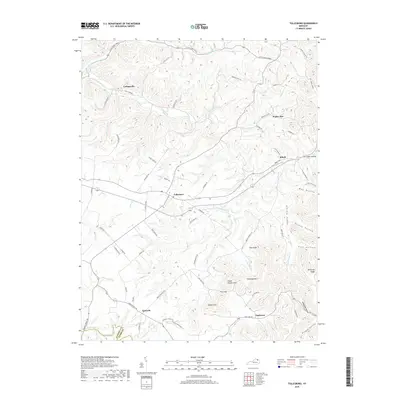
2019 Map of Tollesboro
USGS Topo · Published 2019About this map
Tollesboro serves as a central hub in this section of Lewis County, where the dendritic drainage patterns of Cabin Creek and its many tributaries like Phillips Cr and Union Br define the landscape. The map reveals a network of small settlements and named hollows that speak to the region's agricultural and rural heritage, including Cottageville to the northwest and Poplar Flat to the northeast. The terrain becomes notably more pronounced toward the southeast, where Eskalapia Mtn and Kentucky Ridge rise above the surrounding valleys. Genealogists and local historians can trace family-named locations such as Peach Orchard Hill and Tanbark Hill, as well as the numerous hollows like May Hollow and Stouts Hollow that have historically sheltered small homesteads along the creeks. The border with Fleming County is also clearly demarcated near the village of Epworth.
Find a feature on this map
79 named features on this map. Tap any name to fly to it.
Don’t see what you’re looking for? This feature index may not catch every label — zoom into the map to look around manually.
Map Details
Editions of this 2019 Tollesboro Map
This is the sole edition of this map. No revisions or reprints were ever made.
Other maps of this area

1919 · Vanceburg
USGS Topo · 1:62,500

1929 · Springdale
USGS Topo · 1:48,000

1935 · Springdale
USGS Topo · 1:62,500

1949 · Vanceburg
USGS Topo · 1:62,500

1949 · Concord
USGS Topo · 1:24,000

1949 · Charters
USGS Topo · 1:24,000

1950 · Charters
USGS Topo · 1:24,000
1951 · Concord
USGS Topo · 1:24,000

1951 · Stricklett
USGS Topo · 1:24,000

1951 · Burtonville
USGS Topo · 1:24,000