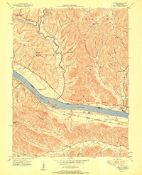
1951 Map of Concord
USGS Topo · Published 1951About this map
The Ohio River dominates this mid-century landscape, acting as a natural boundary between the riverfront communities of Kentucky and Ohio. Along the southern bank, the Chesapeake and Ohio railroad corridor anchors small settlements such as Concord and Rome, where the Rome Station and Chalkley Station provided vital rail connections for the local river-and-rail economy. The interior of the region is defined by a dense network of steep hollows and ridges, such as East Gift Ridge and Big Brier Knob, which shaped the distribution of small farmstead clusters and community centers. Local life at this time was centered around scattered institutions like the Beasley Fork School and Taylor Chapel. These isolated valleys, from Smoky Creek to the deep Truitt Hollow, supported small populations that relied on the intricate drainage system of Brush Creek and its many tributaries.
Find a feature on this map
67 named features on this map. Tap any name to fly to it.
Don’t see what you’re looking for? This feature index may not catch every label — zoom into the map to look around manually.
Map Details
Editions of this 1951 Concord Map
2 editions found
Other maps of this area

1916 · Peebles
USGS Topo · 1:62,500

1918 · Peebles
USGS Topo · 1:62,500

1918 · Seaman
USGS Topo · 1:62,500

1919 · Vanceburg
USGS Topo · 1:62,500

1929 · Springdale
USGS Topo · 1:48,000

1935 · Springdale
USGS Topo · 1:62,500

1949 · Vanceburg
USGS Topo · 1:62,500

1949 · Buena Vista
USGS Topo · 1:24,000

1949 · Vanceburg
USGS Topo · 1:24,000

1949 · Concord
USGS Topo · 1:24,000