1952 Map of Tomahawk
USGS Topo · Published 1952About this map
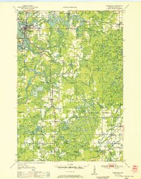
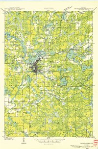
The Wisconsin River defines the industrial and natural character of this northern Wisconsin landscape, where early 1950s infrastructure supports the timber and paper-rich region. Tomahawk serves as the primary hub, surrounded by a complex network of reservoirs including the Jersey City Flowage and Lake Mohawksin. Engineering of the river is evident at Kings Dam and Grandmother Dam, which regulated water flow for local needs.
Find a feature on this map
111 named features on this map. Tap any name to fly to it.
Don’t see what you’re looking for? This feature index may not catch every label — zoom into the map to look around manually.
Map Details
Editions of this 1952 Tomahawk Map
This is the sole edition of this map. No revisions or reprints were ever made.
Other maps of this area

1899 · Wausau
USGS Topo · 1:125,000

1902 · Wausau
USGS Topo · 1:125,000

1902 · Marathon
USGS Topo · 1:125,000

1939 · Mc Cord
USGS Topo · 1:48,000

1939 · Cassian
USGS Topo · 1:48,000

1940 · Parrish
USGS Topo · 1:48,000

1940 · Rhinelander
USGS Topo · 1:48,000

1942 · Cassian
USGS Topo · 1:48,000

1947 · Mc Cord
USGS Topo · 1:48,000
1949 · Rhinelander
USGS Topo · 1:48,000