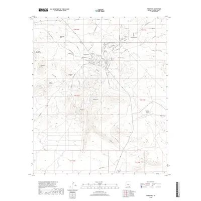
2018 Map of Tombstone
USGS Topo · Published 2018About this map
Tombstone remains the central focus of this landscape, surrounded by the high-desert terrain of the Tombstone Hills and The Three Brothers Hills. The legendary history of the area is anchored by the presence of Boothill Graveyard and Tombstone Cem, reflecting its 19th-century boom years. Modern infrastructure is visible through the Tombstone Municipal Airport and the Rancho San Marcos Airport, while the natural drainage patterns of Walnut Gulch and Emerald Gulch cross the arid flats. Numerous named heights such as Military Hill, Uncle Sam Hill, and Ajax Hill suggest a legacy of strategic observation and local mining exploration. This 2018 survey documents the persistent layout of the town's grid against the surrounding drainages like Tombstone Gulch and Reeves Cr, providing a precise look at the modern footprint of one of the West's most famous settlements.
Find a feature on this map
66 named features on this map. Tap any name to fly to it.
Don’t see what you’re looking for? This feature index may not catch every label — zoom into the map to look around manually.
Map Details
Editions of this 2018 Tombstone Map
This is the sole edition of this map. No revisions or reprints were ever made.
Other maps of this area

1915 · Benson
USGS Topo · 1:125,000

1916 · Pearce
USGS Topo · 1:125,000

1922 · St. David
USGS Topo · 1:62,500

1925 · Gleeson
USGS Topo · 1:62,500

1926 · Courtland
USGS Topo · 1:62,500

1932 · Fairbank
USGS Topo · 1:62,500

1943 · Benson
USGS Topo · 1:125,000

1952 · Tombstone SE
USGS Topo · 1:24,000
1952 · Lewis Springs
USGS Topo · 1:24,000
1952 · Fairbank
USGS Topo · 1:24,000