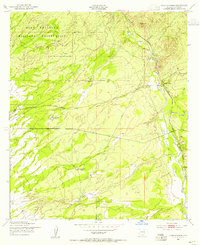
1952 Map of Lewis Springs
USGS Topo · Published 1955About this map
The San Pedro River valley in the early 1950s is defined by a sparse but vital network of water sources and cattle operations in this section of Cochise County. This landscape, much of which falls within the Fort Huachuca Military Reservation, is anchored by the Southern Pacific railroad line as it cuts through the scrubland. Named ranching homesteads such as the Donnet-Fry Ranch, Schrader Ranch, and Bakarich-McCool Ranch reflect the mid-century ranching economy that shaped this borderland territory. The topography varies from the wide plains of the San Rafael Del Valle to distinct landmarks like Bronco Hill. Cultural markers like Graveyard Gulch and the small siding at Lewis Springs provide specific touchpoints for local family history and the geographic footprint of the era's land use.
Find a feature on this map
13 named features on this map. Tap any name to fly to it.
Don’t see what you’re looking for? This feature index may not catch every label — zoom into the map to look around manually.
Map Details
Editions of this 1952 Lewis Springs Map
4 editions found
Other maps of this area

1914 · Hereford
USGS Topo · 1:125,000

1915 · Benson
USGS Topo · 1:125,000

1922 · Sunnyside
USGS Topo · 1:62,500

1932 · Stark
USGS Topo · 1:62,500

1932 · Fairbank
USGS Topo · 1:62,500

1938 · Huachuca
USGS Topo · 1:62,500

1938 · Sunnyside
USGS Topo · 1:62,500

1943 · Benson
USGS Topo · 1:125,000

1948 · Fort Huachuca NE
USGS Topo · 1:24,000

1948 · Miller Peak
USGS Topo · 1:24,000