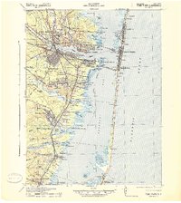
1941 Map of Toms River
USGS Topo · Published 1941About this map
Toms River flows into the expansive Barnegat Bay at a time when the Jersey Shore was rapidly developing its identity as a recreational and industrial hub. The landscape is a network of coastal settlements and inland pine forests, where the Pennsylvania RR and Central RR of New Jersey converge to facilitate transit across the marshy reaches of Dover, Berkeley, and Lacey. Prominent institutional footprints like the Royal Pines Hospital and the Cedar Crest Private School appear alongside recreational spaces such as Cranmoor Country Club and the Pinewald Golf Course, reflecting a mid-century shift toward leisure-based development.
Find a feature on this map
85 named features on this map. Tap any name to fly to it.
Don’t see what you’re looking for? This feature index may not catch every label — zoom into the map to look around manually.
Map Details
Editions of this 1941 Toms River Map
2 editions found

Other maps of this area

1884 · Whitings
USGS Topo · 1:62,500

1888 · Barnegat
USGS Topo · 1:62,500

1888 · Little Egg Harbor
USGS Topo · 1:62,500

1888 · Asbury Park
USGS Topo · 1:62,500

1888 · Cassville
USGS Topo · 1:62,500

1888 · Long Beach
USGS Topo · 1:62,500

1888 · Whitings
USGS Topo · 1:62,500

1893 · Little Egg Harbor
USGS Topo · 1:62,500

1893 · Asbury Park
USGS Topo · 1:62,500

1893 · Long Beach
USGS Topo · 1:62,500