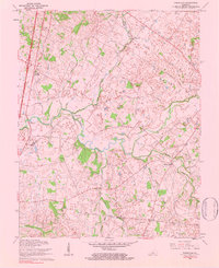
1979 Map of Tonieville
USGS Topo · Published 1983About this map
The Middle Fork Nolin River winds through this central Kentucky landscape, a terrain defined by the drainage patterns of numerous branches and runs as they move toward the main channel. Published in 1983 based on 1960 revisions and 1979 inspections, the map shows a network of rural settlements and agricultural hubs like Glendale Junction, Tonieville, and Eagle Mills. This era of the region’s development is characterized by prominent roadway alignments like Airline Road and the Central Tonieville Road, which connect isolated churches such as Siberia Ch and St Anthonys Ch to the larger river economy. Local industry and land use are evidenced by the Mathers Mills site and a specialized Fish Hatchery, while the presence of the Illinois Pipeline cutting across the county line between Hardin Co and Larue Co signals the modern energy infrastructure overlaying this historic rural grid.
Find a feature on this map
33 named features on this map. Tap any name to fly to it.
Don’t see what you’re looking for? This feature index may not catch every label — zoom into the map to look around manually.
Map Details
Editions of this 1979 Tonieville Map
This is the sole edition of this map. No revisions or reprints were ever made.
Other maps of this area

1934 · Munfordville
USGS Topo · 1:48,000

1935 · Elizabethtown
USGS Topo · 1:48,000

1937 · Munfordville
USGS Topo · 1:62,500

1938 · Elizabethtown
USGS Topo · 1:62,500

1948 · Cecilia
USGS Topo · 1:24,000

1949 · Sonora
USGS Topo · 1:24,000

1949 · Tonieville
USGS Topo · 1:24,000

1949 · Elizabethtown
USGS Topo · 1:24,000
1949 · Elizabethtown
USGS Topo · 1:62,500

1953 · Nelsonville
USGS Topo · 1:24,000