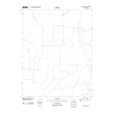
2010 Map of Toonerville SE
USGS Topo · Published 2010About this map
Caddoa Creek and Snif Creek define the drainage patterns of this rural landscape in Bent County, southeastern Colorado. The map reflects a highly organized rural infrastructure, dominated by a strict grid of county roads such as County Road R and County Road N. The presence of fractional road designations like County Rd-17.25 and County Rd-18 4/10 suggests a precise surveying history, likely dictated by the specific needs of local landholders and agricultural boundaries. Topographic features such as Penrose Draw and Hood Draw intersect the grid, illustrating the natural watercourses that intermittent rains follow through this arid terrain. This 2010 edition by the U.S. Geological Survey provides a detailed look at the modern rural layout before any further regional development or land-use changes.
Find a feature on this map
17 named features on this map. Tap any name to fly to it.
Don’t see what you’re looking for? This feature index may not catch every label — zoom into the map to look around manually.
Map Details
Editions of this 2010 Toonerville SE Map
This is the sole edition of this map. No revisions or reprints were ever made.
Other maps of this area

1891 · Higbee
USGS Topo · 1:125,000

1892 · Two Butte
USGS Topo · 1:125,000

1893 · Higbee
USGS Topo · 1:125,000

1893 · Two Butte
USGS Topo · 1:125,000

1955 · La Junta
USGS Topo · 1:250,000

1958 · La Junta
USGS Topo · 1:250,000

1966 · Toonerville SE
USGS Topo · 1:24,000
1966 · Gilpin
USGS Topo · 1:24,000
1966 · Toonerville
USGS Topo · 1:24,000
1966 · Toonerville NE
USGS Topo · 1:24,000