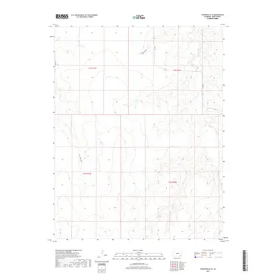
2019 Map of Toonerville SE
USGS Topo · Published 2019About this map
Caddoa Cr meanders through the eastern section of this Colorado landscape, highlighting the intricate drainage patterns characteristic of Bent County. The area is defined by intermittent watercourses like Snif Cr and Hood Draw, which carve through the high plains terrain. A grid of rural routes, including Co Rd 19 and Co Rd R, provides access to the expansive rangelands that comprise most of this territory. In the western portion, Penrose Draw runs southward, illustrating the subtle topographical variations in this part of the Arkansas River watershed. The map details the Public Land Survey System divisions, such as t25s r51w and t26s r50w, which have historically dictated land ownership and agricultural use in the American West.
Find a feature on this map
13 named features on this map. Tap any name to fly to it.
Don’t see what you’re looking for? This feature index may not catch every label — zoom into the map to look around manually.
Map Details
Editions of this 2019 Toonerville SE Map
This is the sole edition of this map. No revisions or reprints were ever made.
Other maps of this area

1891 · Higbee
USGS Topo · 1:125,000

1892 · Two Butte
USGS Topo · 1:125,000

1893 · Higbee
USGS Topo · 1:125,000

1893 · Two Butte
USGS Topo · 1:125,000

1955 · La Junta
USGS Topo · 1:250,000

1958 · La Junta
USGS Topo · 1:250,000

1966 · Toonerville SE
USGS Topo · 1:24,000
1966 · Gilpin
USGS Topo · 1:24,000
1966 · Toonerville
USGS Topo · 1:24,000
1966 · Toonerville NE
USGS Topo · 1:24,000