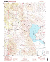
1988 Map of Topaz Lake
USGS Topo · Published 1989About this map
Topaz Lake dominates this high-desert landscape along the border of Nevada and California, serving as a focal point for water management and recreation in the late 20th century. The map details a complex network of agricultural irrigation in the Antelope Valley, where the Wiley Ditch, Swager Ditch, and Alkali Ditch divert water toward the West Slough. These man-made features contrast with the steep, mining-scarred terrain of the Toiyabe National Forest to the west. Evidence of the region’s mineral history is visible at the Willard-McDonald Mine and the Leviathan Lookout atop Leviathan Peak. For genealogists and local historians, the inclusion of named locations like Virgil Connell Spring and Company Meadows provides specific geographic markers of early land use and family-named landmarks. The historic Von Schmidt Boundary also appears, marking the legacy of 19th-century surveying disputes between the two states.
Find a feature on this map
43 named features on this map. Tap any name to fly to it.
Don’t see what you’re looking for? This feature index may not catch every label — zoom into the map to look around manually.
Map Details
Editions of this 1988 Topaz Lake Map
2 editions found
Other maps of this area

1889 · Markleeville
USGS Topo · 1:125,000

1891 · Markleeville
USGS Topo · 1:125,000

1891 · Wellington
USGS Topo · 1:125,000

1893 · Markleeville
USGS Topo · 1:125,000

1893 · Wellington
USGS Topo · 1:125,000

1948 · Walker Lake
USGS Topo · 1:250,000

1956 · Desert Creek Peak
USGS Topo · 1:62,500

1956 · Topaz Lake
USGS Topo · 1:62,500

1957 · Walker Lake
USGS Topo · 1:250,000

1957 · Wellington
USGS Topo · 1:62,500