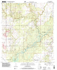
1998 Map of Topsy
USGS Topo · Published 2002About this map
The Calcasieu River meanders through a landscape of bayous and wetlands where the boundaries of Allen, Jefferson Davis, and Calcasieu Parishes converge. This late 20th-century survey illustrates the intricate water network of southwestern Louisiana, featuring the Old River Bay, Pinto Cutoff, and the Old Barnes Creek Cutoff. These bypasses and oxbows reflect the dynamic nature of the river system as it flows toward Joe Cooley Bay.
Find a feature on this map
33 named features on this map. Tap any name to fly to it.
Don’t see what you’re looking for? This feature index may not catch every label — zoom into the map to look around manually.
Map Details
Editions of this 1998 Topsy Map
This is the sole edition of this map. No revisions or reprints were ever made.
Other maps of this area

1935 · Moss Bluff
USGS Topo · 1:31,680

1935 · Gaytine
USGS Topo · 1:31,680

1935 · Longville
USGS Topo · 1:31,680

1947 · Gaytine
USGS Topo · 1:31,680

1947 · Fenton
USGS Topo · 1:31,680

1947 · Moss Bluff
USGS Topo · 1:31,680

1947 · Hecker
USGS Topo · 1:31,680

1947 · Le Blanc
USGS Topo · 1:31,680

1947 · Edna
USGS Topo · 1:31,680

1947 · Reeves
USGS Topo · 1:31,680