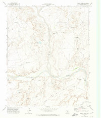
1971 Map of Torrey House
USGS Topo · Published 1974About this map
Canadian River waters cut through the high plains of Oldham County, defining a landscape of deep canyons and seasonal drainages. During this early 1970s survey, the area was characterized by wide-ranging cattle ranching operations, marked by a network of essential water sources like Rita Blanca Tank, Blue Dam Tank, and numerous windmills such as the Coyote Windmill. The map captures the remnants of earlier habitation at the Torrey House (Ruins) and active outposts including Bird Farm Camp and Isabelle Camp. Significant landforms like Torrey Flats and Elephant Head stand above the drainage basins of Punta de Agua Creek and Los Redos Creek. These features, along with historic passage points like Hollicott Crossing, illustrate the enduring relationship between water access and settlement in the Texas Panhandle.
Find a feature on this map
28 named features on this map. Tap any name to fly to it.
Don’t see what you’re looking for? This feature index may not catch every label — zoom into the map to look around manually.
Map Details
Editions of this 1971 Torrey House Map
This is the sole edition of this map. No revisions or reprints were ever made.
Other maps of this area

1954 · Tucumcari
USGS Topo · 1:250,000

1958 · Tucumcari
USGS Topo · 1:250,000

1966 · Alamocitos Camp
USGS Topo · 1:24,000

1966 · Halfway Creek
USGS Topo · 1:24,000

1966 · Torrea Peak
USGS Topo · 1:24,000

1971 · Proctor Ranch
USGS Topo · 1:24,000

1971 · Channing NW
USGS Topo · 1:24,000

1971 · Many Post Camp
USGS Topo · 1:24,000

1971 · Boys Ranch West
USGS Topo · 1:24,000
1971 · Channing
USGS Topo · 1:24,000