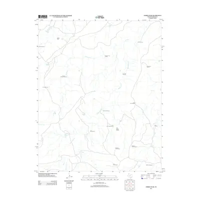
2012 Map of Torrey Peak
USGS Topo · Published 2012About this map
Torrey Peak rises above a landscape defined by an intricate network of ephemeral watercourses and vital ranching infrastructure in western Oldham County. The terrain is dominated by the seasonal drainages of Alamosa Cr, Billys Cr, and Ledger Cr, which carve through the high plains. Human presence is marked primarily by scattered windmills and water tanks essential for livestock management, such as the Lost Cabin Windmill, Espendiza Windmill, and Big Torrey Tank. To the south, The Cedar Brakes indicates a shift in vegetation and topography, supported by localized infrastructure like the Big Cedar Brake Windmill. The inclusion of Torrey Peak Camp and numerous named pastures, such as those served by the Middle Trap Windmill, provides a detailed look at the sprawling ranching operations that characterize this section of the Texas Panhandle in the early 21st century.
Find a feature on this map
28 named features on this map. Tap any name to fly to it.
Don’t see what you’re looking for? This feature index may not catch every label — zoom into the map to look around manually.
Map Details
Editions of this 2012 Torrey Peak Map
This is the sole edition of this map. No revisions or reprints were ever made.
Other maps of this area

1954 · Tucumcari
USGS Topo · 1:250,000

1958 · Tucumcari
USGS Topo · 1:250,000

1966 · Alamocitos Camp
USGS Topo · 1:24,000

1966 · Jay Taylor Ranch
USGS Topo · 1:24,000

1966 · Halfway Creek
USGS Topo · 1:24,000

1966 · Landergin
USGS Topo · 1:24,000

1966 · Torrea Peak
USGS Topo · 1:24,000
1966 · Vega North
USGS Topo · 1:24,000

1971 · Many Post Camp
USGS Topo · 1:24,000

1971 · Boys Ranch West
USGS Topo · 1:24,000