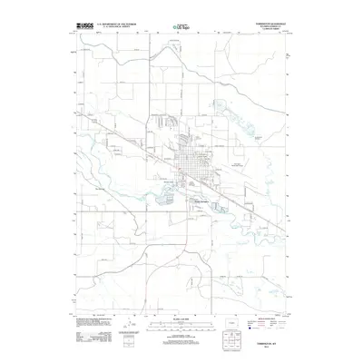
2012 Map of Torrington
USGS Topo · Published 2012About this map
The N Platte River anchors this Goshen County landscape, winding through a valley shaped by early twenty-first-century infrastructure and agricultural water management. Modern development is concentrated around South Torrington, where residential grids such as Presidential Estates Rd meet historic institutional landmarks like Saint Josephs Orphanage and the Valley View Cem. The irrigation network, vital to this region's high-plains farming, is prominently marked by the Interstate Canal and the Arnold Reservoir with its associated Arnold Draft Spillway. Aviation and recreation also define the area, evidenced by the Torrington Municipal Airport and the expansive green spaces of Jirdon Park and Pioneer Park. This survey reflects the organized expansion of a Wyoming trade hub at a time when traditional water rights and modern transport converged.
Find a feature on this map
107 named features on this map. Tap any name to fly to it.
Don’t see what you’re looking for? This feature index may not catch every label — zoom into the map to look around manually.
Map Details
Editions of this 2012 Torrington Map
This is the sole edition of this map. No revisions or reprints were ever made.
Other maps of this area

1896 · Patrick
USGS Topo · 1:125,000

1899 · Goshen Hole
USGS Topo · 1:125,000

1954 · Torrington
USGS Topo · 1:250,000

1954 · Cheyenne
USGS Topo · 1:250,000

1958 · Cheyenne
USGS Topo · 1:250,000

1958 · Torrington
USGS Topo · 1:250,000

1960 · Huntley
USGS Topo · 1:24,000

1960 · Lyman
USGS Topo · 1:24,000
1960 · Cottier
USGS Topo · 1:24,000
1960 · Yoder
USGS Topo · 1:24,000