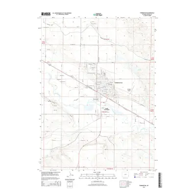
2015 Map of Torrington
USGS Topo · Published 2015About this map
The North Platte River winds through this High Plains landscape, anchoring the development of Torrington and South Torrington. The area's reliance on water management is evident in the sprawling network of irrigation infrastructure, including the Interstate Canal and Arnold Reservoir, which support the agricultural economy of the Goshen Hole region. The town serves as a regional hub, evidenced by the campus of Eastern Wyoming College and the Torrington Municipal Airport located east of the city center.
Find a feature on this map
98 named features on this map. Tap any name to fly to it.
Don’t see what you’re looking for? This feature index may not catch every label — zoom into the map to look around manually.
Map Details
Editions of this 2015 Torrington Map
This is the sole edition of this map. No revisions or reprints were ever made.
Other maps of this area

1896 · Patrick
USGS Topo · 1:125,000

1899 · Goshen Hole
USGS Topo · 1:125,000

1954 · Torrington
USGS Topo · 1:250,000

1954 · Cheyenne
USGS Topo · 1:250,000

1958 · Cheyenne
USGS Topo · 1:250,000

1958 · Torrington
USGS Topo · 1:250,000

1960 · Huntley
USGS Topo · 1:24,000

1960 · Lyman
USGS Topo · 1:24,000
1960 · Cottier
USGS Topo · 1:24,000
1960 · Yoder
USGS Topo · 1:24,000