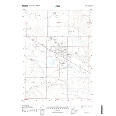
2017 Map of Torrington
USGS Topo · Published 2017About this map
The North Platte River carves a path through this Goshen County landscape, where the agricultural heart of eastern Wyoming meets the growing infrastructure of Torrington. The map details the town's core and its extension into South Torrington, illustrating a community anchored by the BNSF Railway and educational institutions like Eastern Wyoming College. Irrigation remains central to the region's character, evidenced by the I- Canal and Arnold Reservoir north of the river, which support the surrounding farmland.
Find a feature on this map
105 named features on this map. Tap any name to fly to it.
Don’t see what you’re looking for? This feature index may not catch every label — zoom into the map to look around manually.
Map Details
Editions of this 2017 Torrington Map
This is the sole edition of this map. No revisions or reprints were ever made.
Other maps of this area

1896 · Patrick
USGS Topo · 1:125,000

1899 · Goshen Hole
USGS Topo · 1:125,000

1954 · Torrington
USGS Topo · 1:250,000

1954 · Cheyenne
USGS Topo · 1:250,000

1958 · Cheyenne
USGS Topo · 1:250,000

1958 · Torrington
USGS Topo · 1:250,000

1960 · Huntley
USGS Topo · 1:24,000

1960 · Lyman
USGS Topo · 1:24,000
1960 · Cottier
USGS Topo · 1:24,000
1960 · Yoder
USGS Topo · 1:24,000