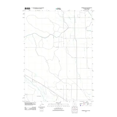
2012 Map of Torrington SE
USGS Topo · Published 2012About this map
The N Platte River valley defines the southwest corner of this landscape, where the alluvial flats of Hunton Meadows signify the vital intersection of water and ranching history in Goshen County. This early 21st-century survey documents an intricate network of irrigation essential to High Plains agriculture, dominated by the sweeping arc of the Interstate Canal. This massive water project, accompanied by secondary systems like Lateral Number 4, Lateral Number 3, and Lateral 7 Main, illustrates how the desert was reclaimed for modern cultivation. Away from the river, the terrain is partitioned by a strict section-line road grid, including Sheep Creek Rd and Co Rd-191, which navigate the drainage of Sheep Cr. This map captures the persistent agrarian character of the Wyoming-Nebraska borderlands just before the centennial of the region's major reclamation projects.
Find a feature on this map
27 named features on this map. Tap any name to fly to it.
Don’t see what you’re looking for? This feature index may not catch every label — zoom into the map to look around manually.
Map Details
Editions of this 2012 Torrington SE Map
This is the sole edition of this map. No revisions or reprints were ever made.
Other maps of this area

1896 · Patrick
USGS Topo · 1:125,000

1898 · Scotts Bluff
USGS Topo · 1:125,000

1899 · Goshen Hole
USGS Topo · 1:125,000

1899 · Whistle Creek
USGS Topo · 1:125,000

1954 · Scottsbluff
USGS Topo · 1:250,000

1954 · Torrington
USGS Topo · 1:250,000

1954 · Cheyenne
USGS Topo · 1:250,000

1955 · Alliance
USGS Topo · 1:250,000

1957 · Alliance
USGS Topo · 1:250,000

1958 · Cheyenne
USGS Topo · 1:250,000