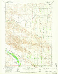
1963 Map of Torrington SE
USGS Topo · Published 1965About this map
The North Platte River flows through a landscape defined by historical passage and sophisticated irrigation systems along the border of Goshen and Sioux counties. The Emigrant Trail traces a path across the southern plains, marked by a Historical Monument and the rail infrastructure of the Chicago Burlington and Quincy railroad. This region in the early 1960s was an intricate network of water management, evidenced by the extensive canal and ditch systems including the Interstate Canal and numerous numbered laterals like Lateral No 1 through Lateral No 8. The settlement of Henry sits near the state line, while agricultural life is anchored by landmarks like Hunton Meadows and local structures including a Sch and Cem. The map reveals the critical link between the river corridor and the high ground of Chalk Buttes, showing how the land was adapted for farming through the Emigrant Trail Burlington Ditch.
Find a feature on this map
28 named features on this map. Tap any name to fly to it.
Don’t see what you’re looking for? This feature index may not catch every label — zoom into the map to look around manually.
Map Details
Editions of this 1963 Torrington SE Map
This is the sole edition of this map. No revisions or reprints were ever made.
Other maps of this area

1896 · Patrick
USGS Topo · 1:125,000

1898 · Scotts Bluff
USGS Topo · 1:125,000

1899 · Goshen Hole
USGS Topo · 1:125,000

1899 · Whistle Creek
USGS Topo · 1:125,000

1954 · Scottsbluff
USGS Topo · 1:250,000

1954 · Torrington
USGS Topo · 1:250,000

1954 · Cheyenne
USGS Topo · 1:250,000

1955 · Alliance
USGS Topo · 1:250,000

1957 · Alliance
USGS Topo · 1:250,000

1958 · Cheyenne
USGS Topo · 1:250,000