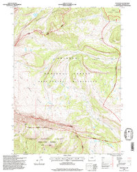
1996 Map of Tosi Peak
USGS Topo · Published 1998About this map
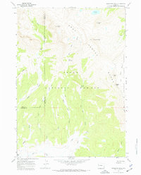
The Gros Ventre Range and Sawtooth Range dominate this high-altitude landscape in the mid-1990s, where the convergence of several protected wilderness areas dictates the terrain's use. Steep ridges like Elk Ridge and Tepee Ridge define the drainage patterns for Tosi Creek and Tepee Creek. The map documents a significant era of land management, clearly delineating the Gros Ventre Wilderness and the Shoal Creek Wilderness Study Area, reflecting the ongoing conservation efforts within the Teton National Forest. Notable landmarks such as Tosi Peak and the high-alpine Water Dog Lakes provide specific points of reference for those studying the geological and hydrological character of this part of Sublette County. Narrow pack trails and forest service routes, including segments of the Jackson Pinedale trail, highlight the area's history as a remote corridor for travel through the Red Hills.
Find a feature on this map
29 named features on this map. Tap any name to fly to it.
Don’t see what you’re looking for? This feature index may not catch every label — zoom into the map to look around manually.
Map Details
Editions of this 1996 Tosi Peak Map
This is the sole edition of this map. No revisions or reprints were ever made.
Other maps of this area

1907 · Gros Ventre
USGS Topo · 1:125,000

1910 · Gros Ventre
USGS Topo · 1:125,000

1955 · Driggs
USGS Topo · 1:250,000

1958 · Driggs
USGS Topo · 1:250,000

1962 · Driggs
USGS Topo · 1:250,000
1966 · Pass Peak
USGS Topo · 1:24,000
1966 · Dodge Butte
USGS Topo · 1:24,000
1967 · Tosi Peak
USGS Topo · 1:24,000
1967 · Doubletop Peak
USGS Topo · 1:24,000
1967 · Raspberry Ridge
USGS Topo · 1:24,000