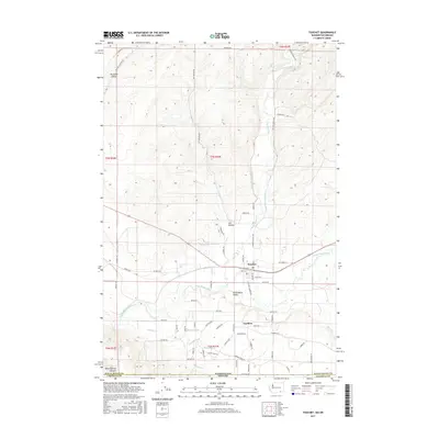
2017 Map of Touchet
USGS Topo · Published 2017About this map
The Touchet River flows southward through a landscape defined by an intricate network of irrigation engineering, meeting the Walla Walla River in the broad Walla Walla Valley. This agricultural corridor is sustained by an extensive system of named waterworks, including the Gardena Ditch, Touchet W Side Ditch, and South Ditch, which redirect water across the arid flats to support the settlements of Touchet and Gardena. To the north and west, the terrain rises into the dissected plateaus of Ninemile Canyon and Ash Hollow, where roads like Ash Hollow Rd follow natural drainages through the high ground. The map also records the jurisdictional boundary where the state of Washington meets Oregon, providing a detailed record of land use and water management in the Pacific Northwest.
Find a feature on this map
69 named features on this map. Tap any name to fly to it.
Don’t see what you’re looking for? This feature index may not catch every label — zoom into the map to look around manually.
Map Details
Editions of this 2017 Touchet Map
This is the sole edition of this map. No revisions or reprints were ever made.
Other maps of this area

1915 · Wallulah
USGS Topo · 1:96,000

1918 · Wallula
USGS Topo · 1:125,000

1935 · Pendleton
USGS Topo · 1:125,000

1953 · Pendleton
USGS Topo · 1:250,000

1953 · Walla Walla
USGS Topo · 1:250,000

1956 · Pendleton
USGS Topo · 1:250,000

1958 · Walla Walla
USGS Topo · 1:250,000

1964 · Zangar Junction
USGS Topo · 1:24,000

1964 · Slater
USGS Topo · 1:24,000
1966 · Smeltz
USGS Topo · 1:24,000