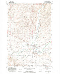
1991 Map of Touchet
USGS Topo · Published 1992About this map
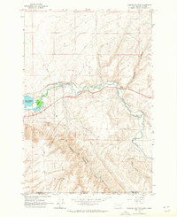
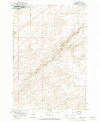
The confluence of the Touchet River and the Walla Walla River anchors this agricultural landscape in the Walla Walla Valley during the late twentieth century. Irrigation is the primary driver of development here, evidenced by an extensive network of water infrastructure including the East Side Touchet Ditch, West Side Touchet Ditch, and the South Ditch, alongside an Aqueduct. The settlement of Touchet serves as a local hub, featuring a prominent Grain Elevator and a Substation near the river fork. Further south, the community of Gardena sits amidst a grid of rural roads such as Byrnes Road and Gardena Road. The terrain transitions from the fertile valley floor to the dissected uplands of Ninemile Canyon and Ash Hollow, while the state border between Washington and Oregon is marked by the Walla Walla Co Umatilla Co boundary.
Find a feature on this map
26 named features on this map. Tap any name to fly to it.
Don’t see what you’re looking for? This feature index may not catch every label — zoom into the map to look around manually.
Map Details
Editions of this 1991 Touchet Map
This is the sole edition of this map. No revisions or reprints were ever made.
Other maps of this area

1915 · Wallulah
USGS Topo · 1:96,000

1918 · Wallula
USGS Topo · 1:125,000

1935 · Pendleton
USGS Topo · 1:125,000

1953 · Pendleton
USGS Topo · 1:250,000

1953 · Walla Walla
USGS Topo · 1:250,000

1956 · Pendleton
USGS Topo · 1:250,000

1958 · Walla Walla
USGS Topo · 1:250,000
1964 · Zangar Junction
USGS Topo · 1:24,000
1964 · Slater
USGS Topo · 1:24,000

1966 · Smeltz
USGS Topo · 1:24,000