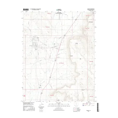
2016 Map of Towaoc
USGS Topo · Published 2016About this map
Towaoc serves as a central hub for the Ute Mountain Ute Reservation, characterized by a structured grid of streets including Chief Ignacio St and Lafayette St. This high-desert landscape is defined by its sophisticated water management systems, essential for life in the Four Corners region. Labels such as Ute Mountain Ditch, Rocky Ford Ditch, and Highline Ditch trace the movement of water across the terrain toward agricultural and residential areas. To the south, the Ute Mountain Tribal Cem stands near the base of the rising highlands.
Find a feature on this map
57 named features on this map. Tap any name to fly to it.
Don’t see what you’re looking for? This feature index may not catch every label — zoom into the map to look around manually.
Map Details
Editions of this 2016 Towaoc Map
This is the sole edition of this map. No revisions or reprints were ever made.
Other maps of this area

1956 · Cortez
USGS Topo · 1:250,000

1957 · Moqui SE
USGS Topo · 1:24,000

1958 · Cortez SW
USGS Topo · 1:24,000

1958 · Sentinel Peak NE
USGS Topo · 1:24,000

1958 · Cortez
USGS Topo · 1:250,000

1959 · Cortez
USGS Topo · 1:250,000

1962 · Cortez
USGS Topo · 1:250,000

1965 · Cortez
USGS Topo · 1:24,000

1966 · Cortez
USGS Topo · 1:250,000
1966 · Moqui Canyon
USGS Topo · 1:24,000