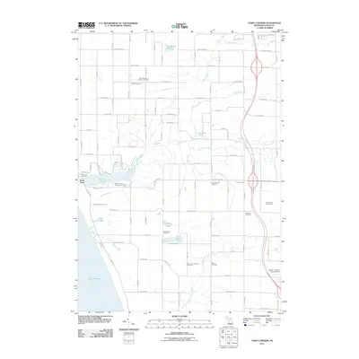
2011 Map of Town Corners
USGS Topo · Published 2011About this map
Lake Michigan borders the western edge of this Oceana County landscape, where the shoreline transition from dunes to agricultural land is marked by numerous small inland waters. The settlement of Stony Lake serves as a focal point near the coast, supported by the Stoney Haven Campground and nearby Stony Lake Cemetery. Moving inland toward the agricultural crossroads of Town Corners, the terrain is defined by a dense network of creeks including Stony Creek, Dorrance Creek, and Burke Creek that feed into Marshville Pond.
Find a feature on this map
55 named features on this map. Tap any name to fly to it.
Don’t see what you’re looking for? This feature index may not catch every label — zoom into the map to look around manually.
Map Details
Editions of this 2011 Town Corners Map
This is the sole edition of this map. No revisions or reprints were ever made.
Other maps of this area

1929 · Montague
USGS Topo · 1:48,000

1931 · Hart NW
USGS Topo · 1:31,680

1931 · Hart SE
USGS Topo · 1:31,680

1931 · Hart NE
USGS Topo · 1:31,680

1954 · Milwaukee
USGS Topo · 1:250,000

1958 · Milwaukee
USGS Topo · 1:250,000

1959 · Montague
USGS Topo · 1:62,500

1959 · Hart
USGS Topo · 1:62,500

1976 · Montague NW
USGS Topo · 1:24,000
1976 · Hart NW
USGS Topo · 1:24,000