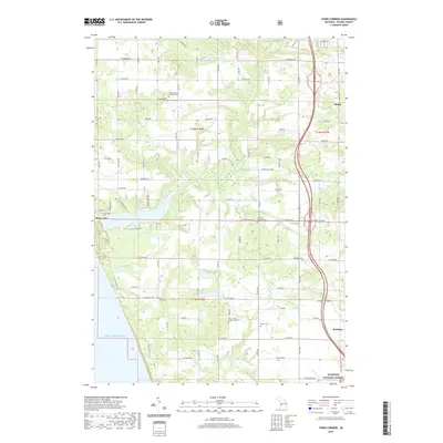
2019 Map of Town Corners
USGS Topo · Published 2019About this map
Lake Michigan forms the western boundary of this coastal landscape, where the shoreline meets a network of small inland lakes and winding creeks. The settlement of Stony Lake serves as a focal point near the coast, while the eastern portion of the map is defined by the corridor of US-31 passing near Shelby and Rothbury. Between these areas lies a rural grid of roads dotted with numerous small cemeteries and parish churches, indicating a well-established community fabric in Oceana County. Genealogy researchers will find several dedicated sites such as Gardner Cem, Cranston Cem, and Saint John's Catholic Cem. The southern edge transitions into the protected timberlands of the Manistee National Forest, where the terrain is drained by the N Br Flower Cr and S Br Flower Cr. This survey illustrates the balance between agricultural layout, coastal recreation, and forest preservation.
Find a feature on this map
65 named features on this map. Tap any name to fly to it.
Don’t see what you’re looking for? This feature index may not catch every label — zoom into the map to look around manually.
Map Details
Editions of this 2019 Town Corners Map
This is the sole edition of this map. No revisions or reprints were ever made.
Other maps of this area

1929 · Montague
USGS Topo · 1:48,000

1931 · Hart NW
USGS Topo · 1:31,680

1931 · Hart SE
USGS Topo · 1:31,680

1931 · Hart NE
USGS Topo · 1:31,680

1954 · Milwaukee
USGS Topo · 1:250,000

1958 · Milwaukee
USGS Topo · 1:250,000

1959 · Montague
USGS Topo · 1:62,500

1959 · Hart
USGS Topo · 1:62,500

1976 · Montague NW
USGS Topo · 1:24,000
1976 · Hart NW
USGS Topo · 1:24,000