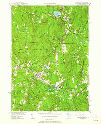
1950 Map of Townsend
USGS Topo · Published 1952About this map
The Squannacook River carves a central path through this mid-century landscape, anchoring the interconnected villages of Townsend, West Townsend, and Townsend Harbor. The Boston and Maine Railroad runs parallel to the river, illustrating the industrial and transit corridor that defined this region of Middlesex County. The map captures a moment when local infrastructure was firmly established, showing the Townsend Sch and Center Ch serving the community, while the Pepperell Waterworks and a nearby Quarry point to the area's resource management and industry.
Find a feature on this map
120 named features on this map. Tap any name to fly to it.
Don’t see what you’re looking for? This feature index may not catch every label — zoom into the map to look around manually.
Map Details
Editions of this 1950 Townsend Map
2 editions found
Other maps of this area

1887 · Fitchburg
USGS Topo · 1:62,500

1889 · Fitchburg
USGS Topo · 1:62,500

1893 · Fitchburg
USGS Topo · 1:62,500

1893 · Groton
USGS Topo · 1:62,500

1900 · Peterboro
USGS Topo · 1:62,500

1906 · Milford
USGS Topo · 1:62,500

1931 · Groton
USGS Topo · 1:48,000

1931 · Fitchburg
USGS Topo · 1:48,000

1935 · Ayer
USGS Topo · 1:24,000

1935 · Groton
USGS Topo · 1:62,500