
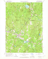
1965 Map of Townsend
USGS Topo · Published 1989About this map
The Squannacook River carves a valley through this landscape, serving as the historical industrial corridor for Townsend and its neighboring villages. The Boston and Maine Railroad follows the river's path, connecting the primary settlements of West Townsend and Townsend Harbor. These villages grew around the water's power, evidenced by features like Cider Mill Pond and Harbor Pond. To the north, the terrain crosses into New Hampshire, where Potanipo Pond and South Brookline define the borderlands. The map reveals a community structured by education and remembrance, featuring the Spaulding Mem Sch and Daniels Academy, alongside several established burial grounds including Hillside Cem and Riverside Cem. Large tracts of the Townsend State Forest illustrate the preservation of the area's timbered hills and wetlands like Dead Swamp.
Find a feature on this map
65 named features on this map. Tap any name to fly to it.
Don’t see what you’re looking for? This feature index may not catch every label — zoom into the map to look around manually.
Map Details
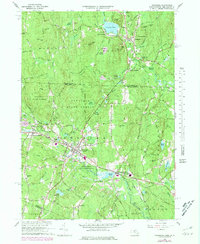
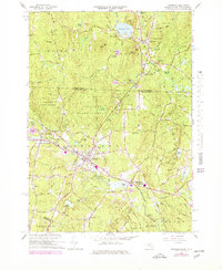
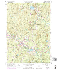
Editions of this 1965 Townsend Map
5 editions found
Other maps of this area

1887 · Fitchburg
USGS Topo · 1:62,500

1889 · Fitchburg
USGS Topo · 1:62,500

1893 · Fitchburg
USGS Topo · 1:62,500

1893 · Groton
USGS Topo · 1:62,500

1900 · Peterboro
USGS Topo · 1:62,500

1906 · Milford
USGS Topo · 1:62,500

1931 · Groton
USGS Topo · 1:48,000

1931 · Fitchburg
USGS Topo · 1:48,000

1935 · Ayer
USGS Topo · 1:24,000

1935 · Groton
USGS Topo · 1:62,500