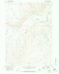
1970 Map of Trabing
USGS Topo · Published 1973About this map
Bozeman Trail history intersects with the high plains of Johnson County on this survey, highlighting the frontier past of Northern Wyoming. The landscape is defined by the convergence of the North Fork Crazy Woman Creek and South Fork Crazy Woman Creek, a site of regional conflict marked by the Crazy Woman Battlefield Historical Marker. This area, once a critical corridor for pioneers and military movement, is anchored by the small settlement of Trabing and the Bozeman Trail Historical Marker. The 1970 landscape also reflects the agricultural necessities of the high desert, showing complex irrigation systems like the Mitchell and Long Ditch and Smith Ditch that draw from the Crazy Woman Creek drainage to water the Colorado Flats.
Find a feature on this map
16 named features on this map. Tap any name to fly to it.
Don’t see what you’re looking for? This feature index may not catch every label — zoom into the map to look around manually.
Map Details
Editions of this 1970 Trabing Map
This is the sole edition of this map. No revisions or reprints were ever made.
Other maps of this area

1900 · Fort McKinney
USGS Topo · 1:125,000

1903 · Fort McKinney
USGS Topo · 1:125,000

1955 · Sheridan
USGS Topo · 1:250,000

1955 · Arminto
USGS Topo · 1:250,000

1958 · Sheridan
USGS Topo · 1:250,000

1958 · Arminto
USGS Topo · 1:250,000

1961 · Antelope Draw
USGS Topo · 1:24,000

1961 · Schlict Draw
USGS Topo · 1:24,000

1961 · Elaine Draw
USGS Topo · 1:24,000

1962 · Sheridan
USGS Topo · 1:250,000