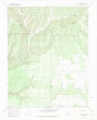
1966 Map of Trail Canyon
USGS Topo · Published 1969About this map
Mesa Verde National Park and the Southern Ute Indian Reservation define this high-altitude landscape in the mid-1960s. The topography is dominated by massive flat-topped features like Big Mesa and Lewis Mountain, carved by the Mancos River and its deep tributaries such as Weber Canyon and Bear Canyon. This survey captures a terrain where ancient history and modern resource management overlap, recording numerous Indian Ruins and Cliff Dwellings alongside water infrastructure like Upper Reservoir and Harrison Reservoir.
Find a feature on this map
33 named features on this map. Tap any name to fly to it.
Don’t see what you’re looking for? This feature index may not catch every label — zoom into the map to look around manually.
Map Details
Editions of this 1966 Trail Canyon Map
3 editions found
Other maps of this area

1895 · La Plata
USGS Topo · 1:62,500

1897 · La Plata
USGS Topo · 1:62,500

1899 · La Plata
USGS Topo · 1:62,500

1908 · La Plata
USGS Topo · 1:62,500

1912 · Soda Canyon
USGS Topo · 1:62,500

1913 · Red Mesa
USGS Topo · 1:62,500

1915 · Soda Canyon
USGS Topo · 1:62,500

1956 · Cortez
USGS Topo · 1:250,000

1958 · Cortez
USGS Topo · 1:250,000

1959 · Cortez
USGS Topo · 1:250,000