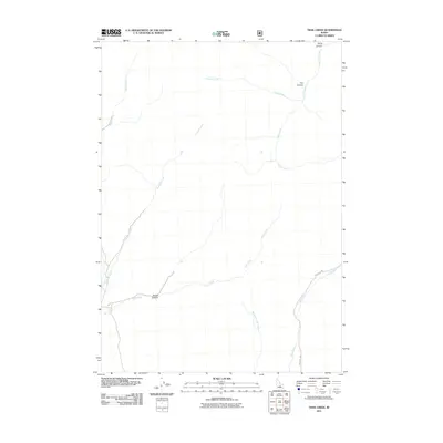
2011 Map of Trail Creek
USGS Topo · Published 2011About this map
Trail Creek and its complex network of tributaries define the high-elevation drainages of Blaine County in this 2011 survey. The landscape is characterized by a series of prominent canyons, including Rough Canyon at the confluence of several streams and Fox Canyon in the northeast. The hydrology of the area is particularly detailed, showing the paths of Friedman Creek, Timber Creek, and Argosy Creek as they navigate the basin. Human presence is sparse, marked primarily by the unimproved path of Fish Creek Rd which follows the course of Fish Creek and West Fork Fish Creek. This map offers an exact record of the high-country water systems before more modern changes, providing a clear view of the natural watercourses like Antelope Creek and Hurst Canyon.
Find a feature on this map
11 named features on this map. Tap any name to fly to it.
Don’t see what you’re looking for? This feature index may not catch every label — zoom into the map to look around manually.
Map Details
Editions of this 2011 Trail Creek Map
This is the sole edition of this map. No revisions or reprints were ever made.
Other maps of this area

1935 · MacKay
USGS Topo · 1:96,000

1955 · Idaho Falls
USGS Topo · 1:250,000

1958 · Idaho Falls
USGS Topo · 1:250,000

1960 · Muldoon Canyon
USGS Topo · 1:62,500

1960 · Grouse
USGS Topo · 1:62,500

1972 · Blizzard Mtn South
USGS Topo · 1:24,000

1978 · Craters Of The Moon
USGS Topo · 1:100,000
1979 · Lake Hills
USGS Topo · 1:24,000
1979 · Fish Creek Reservoir
USGS Topo · 1:24,000
1988 · Arco
USGS Topo · 1:100,000