Loading...
Loading map...1988 Map of Arco
USGS Topo · Published 1989About this map
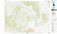
The Big Lost River Valley forms the central axis of this landscape, carving a wide agricultural corridor through the high desert of southeast Idaho. In the late 1980s, the town of Arco sits as a vital junction near the southeastern edge, where the Union Pacific rail line terminates. The valley is dotted with small agricultural settlements like Moore, Darlington, and Leslie, reflecting the irrigation-dependent economy tied to the Big Lost River and the Mackay Reservoir.
Find a feature on this map
62 named features on this map. Tap any name to fly to it.
Don’t see what you’re looking for? This feature index may not catch every label — zoom into the map to look around manually.
Map Details
Date Portrayed1988
Date Published1989
PublisherU.S. Geological Survey
Map TypeTopographic
Scale1:100,000
Physical Dimensions40 x 24.1 inches
Editions of this 1988 Arco Map
This is the sole edition of this map. No revisions or reprints were ever made.
Historical Maps of Arco Through Time
1 maps found
Featured Locations
Source Details
SourceU.S. Geological Survey
CopyrightPublic Domain