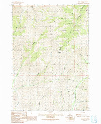
1991 Map of Trail Creek
USGS Topo · Published 1991About this map
The high-elevation boundaries of Sawtooth National Forest and Challis National Forest converge in this high-country landscape where Blaine, Custer, and Butte Counties meet. This 1991 provisional survey captures a remote wilderness defined by a complex drainage system, including Argosy Creek and Friedman Creek, which cut through deep terrain before reaching the Fish Creek basin. Evidence of resource exploration is sparse but present, notably at a high-elevation Mine Shaft located near the headwaters of Argosy Creek. The map documents a network of primitive transportation, where 4WD tracks and designated trails like the Pack Trail navigate the steep rises of Telfer Canyon and Grannys Canyon. The transition between national forests and the convergence of county lines highlights the area's significance for administrative and land-management history.
Find a feature on this map
29 named features on this map. Tap any name to fly to it.
Don’t see what you’re looking for? This feature index may not catch every label — zoom into the map to look around manually.
Map Details
Editions of this 1991 Trail Creek Map
This is the sole edition of this map. No revisions or reprints were ever made.
Other maps of this area

1935 · MacKay
USGS Topo · 1:96,000

1955 · Idaho Falls
USGS Topo · 1:250,000

1958 · Idaho Falls
USGS Topo · 1:250,000

1960 · Muldoon Canyon
USGS Topo · 1:62,500

1960 · Grouse
USGS Topo · 1:62,500

1972 · Blizzard Mtn South
USGS Topo · 1:24,000

1978 · Craters Of The Moon
USGS Topo · 1:100,000
1979 · Lake Hills
USGS Topo · 1:24,000
1979 · Fish Creek Reservoir
USGS Topo · 1:24,000
1988 · Arco
USGS Topo · 1:100,000