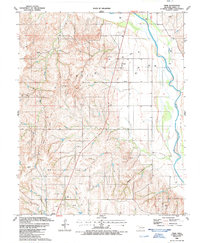
1987 Map of Trail
USGS Topo · Published 1987About this map
The Canadian River defines the eastern boundary of this Dewey County landscape, carving a wide path through the Oklahoma terrain. In the late 1980s, the region was heavily shaped by its energy resources, evidenced by the numerous Oil Wells and Gas Wells dotting the hills. The legacy of earlier transportation is etched across the map as an Old Railroad Grade that cuts diagonally across the center, passing near the Trail Cem. This combination of active extraction and obsolete rail infrastructure illustrates the shifting economic focus of the area during the late twentieth century. Smaller watercourses like Teepee Creek, Red Creek, and Mouse Hollow drain into the river system, while a prominent Water Tank serves as a landmark on the western edge of the survey area.
Find a feature on this map
17 named features on this map. Tap any name to fly to it.
Don’t see what you’re looking for? This feature index may not catch every label — zoom into the map to look around manually.
Map Details
Editions of this 1987 Trail Map
This is the sole edition of this map. No revisions or reprints were ever made.
Other maps of this area

1955 · Clinton
USGS Topo · 1:250,000

1955 · Woodward
USGS Topo · 1:250,000

1957 · Clinton
USGS Topo · 1:250,000

1958 · Woodward
USGS Topo · 1:250,000

1961 · Leedey
USGS Topo · 1:62,500

1962 · Aledo
USGS Topo · 1:62,500

1969 · Mutual SW
USGS Topo · 1:24,000

1969 · Camargo
USGS Topo · 1:24,000
1970 · Vici SW
USGS Topo · 1:24,000

1984 · Foss Reservoir
USGS Topo · 1:100,000